Sunday, March 31, 2013

Postcard Project: Week 7

For background on the Postcard Project, please see the introductory post.

Conemaugh Viaduct

Staple Bend Tunnel

The conclusion of this year’s project consists of two historically important scenes that I photographed along the Path of the Flood Trail [PDF], which follows the path of the Great Flood of 1889 from the failed South Fork Dam to downtown Johnstown.

Sunday, March 24, 2013

Postcard Project: Week 6

For background on the Postcard Project, please see the introductory post.

Johnstown Flood National Memorial

The Deyarmin Building
Home of the St. Michael campus of The Good Shepherd Dog Training.

Finally some “postcard skies” earlier this week. I had a couple of additional shots planned for Saturday, when the weather was decent, but I came down with a cold, and wasn’t up for walking a few miles with my gear. Maybe next week. In the meantime, we are once again under a Winter Storm Warning, with 4–8” of snow expected tonight and tomorrow.

I’ve been using Timehop to see my social media history from past years, and it mostly consists of last year’s Lenten project. The contrast in weather is shocking and depressing.

Sunday, March 17, 2013

Postcard Project: Week 5

For background on the Postcard Project, please see the introductory post.

Peoples Natural Gas Park

Croyle Township Municipal Building

Well, this was a tough week for postcards. The solid white skies continue almost every day, and we’re even under a Winter Storm Warning tonight. Overcast and muddy is pretty much the theme. It’s a big change from last year, and it makes it hard to get the “picture postcard” look for the area’s attractions. I had more luck shooting the details than the sweeping vistas.

Sunday, March 10, 2013

Postcard Project: Week 4

For background on the Postcard Project, please see the introductory post.

Johnstown Inclined Plane

US Route 22, Mundy's Corner

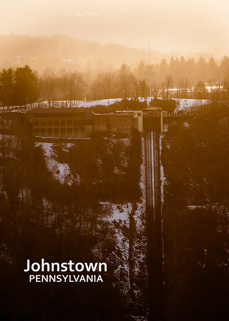
The photograph of the Inclined Plane (top) was made during an effort to photograph Comet PanSTARRS Saturday night. The comet has just become visible in the northern hemisphere, and is very close to the sun. On Saturday, it was to be just 5° above the horizon 30 minutes after sunset.

I planned a shot from somewhere I’d never been: Cover Hill, between the Little Conemaugh and Stonycreek rivers. There’s a radio tower there, and paths to power line rights-of-way. From that vantage point, the comet would have set directly over the top of the Inclined Plane. The sightlines from that area were moderately good; trees kept me from going much wider than you see above.

Unfortunately, cirrus clouds accumulated in the west as sunset approached, and the comet was never visible. The weather forecast for the next few days is worse, so I may not get to see this one. But I was able to get an interesting shot of the Inclined Plane against the sunset light, from an unusual vantage point (eye-level to the top).

This may be the last week for the Pentax K10D… something new (to me) is coming. More on that later.